Official websites use .gov
A .gov website belongs to an official government organization in the United States.

Secure .gov websites use HTTPS
A lock ( ) or https:// means you’ve safely connected to the .gov website. Share sensitive information only on official, secure websites.

Extreme Events Program

GOMO’s Extreme Events program supports hurricane research by 1) sponsoring advancements in hurricane ocean observing technologies and ocean data integration, and 2) enhancing coordination between the ocean and atmospheric observing and modeling communities to produce more accurate and reliable forecasts and improve disaster preparedness.

Mitigating the societal and economic impacts of extreme events are a national priority

Global ocean conditions profoundly affect Earth’s climate and weather on interannual, seasonal, and short time scales. Hurricanes, tropical cyclones and other extreme events are among the most destructive natural disasters. These storms pose major risks to coastal communities and cost billions of dollars each year in damages. Impacts from extreme events are expected to increase with warming oceans, rising sea levels, and growing coastal populations.

Improving our ability to monitor and understand the oceanic and atmospheric conditions driving extreme weather events is imperative to predicting and forecasting hurricanes and other natural disasters. This will allow greater lead times to prepare for and mitigate the effects on oncoming storms, enhance protection of life and property, and reduce the economic and societal impact of hurricanes and other extreme events.

Storm surge during Hurricane Ike in 2008. (Credit: NOAA)

Damages near Mexico Beach, Florida after Category 5 Hurricane Michael made landfall in 2018. (Credit: NOAA)

Vessels and other debris in a Panama City, Florida, marina following Hurricane Michael in 2018. (Credit: NOAA)

Ocean observations are a key component to improve hurricane forecasting

NOAA has a long history of leading hurricane observing, research, and forecasting. Advancements in atmospheric and aircraft operations have led to considerable improvements in forecasting hurricane tracks, providing critical information on where and when a storm will make landfall. Yet forecasts of hurricane intensity have not improved to the same degree, especially when storms rapidly intensify. Decades of research have shown that the ocean is a key component in tropical weather systems and plays a major role in hurricane intensification. However, the collection and integration of ocean data into hurricane models currently lags behind that for atmospheric data, leaving a gap in our ability to reliably forecast the strength of oncoming storms.

Observing the ocean helps us monitor changes over time and better understand the role the ocean plays in extreme events like hurricanes, floods, and droughts. In addition to directly observing hurricanes as they are happening, collecting a sustained, long-term record of ocean data helps us better understand the processes driving extreme weather so that we can predict and prepare for oncoming storms. NOAA uses a suite of tools and observing platforms to monitor ocean features that play a role in hurricane intensification to improve models and forecasts.

Ocean heat provides fuel for hurricanes to develop and gain strength

The amount and availability of ocean heat depends on conditions of the upper ocean, mainly temperature and density (salinity) structure. 

Interactions at the air-sea interface, including waves and sea spray, affect how much heat is transferred from the ocean to the atmosphere to drive hurricane intensification.

Hurricanes draw their energy from warm surface waters. As they pass over warm surface waters with high density stratification that prevents mixing with cooler deep waters, hurricanes can gain strength and intensify. (Image credit: Natalie Renier, Woods Hole Oceanographic Institution)

Essential Ocean Features

Initial conditions are the starting point of any forecasts, and these can be improved by integrating accurate ocean observations. NOAA monitors several essential ocean features that greatly influence upper ocean conditions (temperature and density structure) that play a major role in hurricane intensification.

These include: 1) the Loop Current in the Gulf of Mexico, a major heat source for storms approaching the Gulf Coast; 2) warm and cold core eddies that can either strengthen or weaken hurricane strength, respectively; and 3) freshwater barrier layers that stratify the water column, preventing vertical mixing with cooler, deeper waters that can weaken storms.

Sustained monitoring of these essential ocean features days to weeks ahead of an approaching storm can improve the forecast’s representation of the ocean and improve initial conditions for more accurate hurricane forecasts.

Essential ocean features influencing hurricane intensification in the Western Atlantic Basin.

Ocean Observing Instruments & Platforms

NOAA uses a suite of tools and observing platforms to directly study hurricanes and to collect observations from essential ocean features that play a role in hurricane development and intensification. Drifters and Argo floats managed by GOMO are ocean observing tools that monitor the ocean year-round, collecting data on temperature, salinity, and other ocean conditions. Data from these platforms can be assimilated into models to set accurate initial conditions for hurricane forecasts, and help us to better understand the impact and response of the ocean before, during, and after hurricanes.

Other observing technologies are strategically deployed during hurricane season to capture key observations. Uncrewed autonomous vehicles, like gliders and Saildrones, are operated in areas where chances of hurricane occurrence are high to collect more detailed information on storms as they develop and intensify. Air-deployed technologies including dropsondes, expendable bathythermographs (XBTs), and uncrewed aircraft drones are launched directly from NOAA’s Hurricane Hunter aircrafts into storms. These tools provide information on sea surface and air temperatures, humidity, and wind speed that improve estimation of the boundary layer and interactions at the air-sea interface.

NOAA coordinates research across government, academic, and private partners to advance technologies that collect ocean and atmospheric data during hurricanes. (Credit: NOAA PMEL)

Coupled Ocean-Atmosphere Hurricane Models

NOAA is advancing the use of coupled models to improve hurricane models and forecasts. A coupled model is one in which two or more components can exchange information between them, more accurately capturing the complex interactions that occur between the ocean and atmosphere during hurricanes.

This information is critical for hurricane forecasting because it helps to predict not only the location where a storm will make landfall, but also the strength of winds and precipitation along its path, as well as anticipated flooding in coastal areas. Research has shown that correctly representing the ocean in these coupled models can improve hurricane intensity predictions by over 50% for certain storms.

Proof-of-concept experiments using coupled ocean–atmosphere numerical models demonstrate the importance of ocean observations in hurricane forecasting. Integration of ocean observations to correctly represent relevant ocean conditions (warm sea surface temperatures, upper ocean heat content, presence of freshwater barriers from river outflow) led to improved intensity forecasting of Hurricane Maria in 2017. Without integrating ocean data, simulated upper ocean conditions that were cooler than reality led models to underpredict the storm’s strength, potentially leading to delayed emergency preparation and response by impacted communities.

Similarly, Hurricane Michael in 2018 was predicted to make landfall as a Category 1 or 2 storm without using ocean observations, based on unfavorable atmospheric conditions. Researchers at AOML used glider observations to show that stratified ocean temperature and salinity led to rapid intensification of Hurricane Michael to a Category 4. These examples emphasize how that integration of ocean data is critical for accurately forecasting hurricane strength and potential impacts.

Realistic ocean modeling led to a more accurate representation of rapid intensification of Hurricane Michael (2018) to a Category 4 storm. (Credit: Le Henaff et al. 2021)

GOMO is leading the coordination and integration of ocean observations across NOAA hurricane research and modeling activities

As the U.S. Federal source and international leader in sustained, in situ global ocean observations, GOMO established the Extreme Events Program with the goal of better coordinating the integration of ocean observations across hurricane research and modeling activities. Building on the rich history of work by NOAA and our partners, the Extreme Events Program leverages GOMO’s existing network of ocean observing platforms, facilitates connections across the hurricane research and operational communities, and sponsors innovative, collaborative research to better understand the ocean’s role in hurricanes and other extreme weather events.

Extreme Events Ocean Observing Task Team

GOMO established the Extreme Events Ocean Observing Task Team (EEOOTT) in 2020 with the goal of bridging the ocean and atmospheric observing and modeling communities. The EEOOTT serves as the unifying organizational infrastructure for NOAA and external partners to coordinate cross-disciplinary ocean observing efforts related to extreme events, with an initial focus on Atlantic hurricanes. The EEOOTT consists of over 30 members across NOAA’s programs, labs, Cooperative Institutes, and other academic partners that meet regularly during hurricane season (June 1st to November 30th) to coordinate hurricane research and monitoring efforts. By fostering communication across partners and disciplines, the EEOOTT aims to improve understanding of the role the ocean, waves, and air-sea interactions play in the development and intensification of hurricanes and other extreme tropical weather events. 

GOMO Extreme Events Program Manager Cheyenne Stienbarger presenting at the 2022 Tropical Cyclone Observations and Research Forum. (Credit: NOAA GOMO)

Coordination of Ocean Observing Platforms

Since 2021, GOMO and our partners have leveraged existing ocean observing technologies and opportunities for co-deployments to simultaneously observe the air-sea transition zone for hurricanes in the Gulf of Mexico, tropical Atlantic, and Caribbean Sea regions. To improve our coordination of ocean observing systems and platforms in these regions, GOMO utilizes a visualization and situational awareness tool called GeoCollaborate, a product of StormCenter Communications, Inc. 

The interactive viewer allows us to see in real-time the locations of ocean and hurricane observation platforms like drifters and Argo floats, gliders, and other marine observations platforms (e.g., vessels and buoys). By comparing where these platforms are in relation to active tropical storms or those flagged for possible formation by the National Hurricane Center, we can leverage platforms already in place and prioritize deployments to better coordinate hurricane observations. There are also layers available to monitor sea surface temperature (SST) and areas with severe lightning to identify where storms may be more likely to occur.

Explore the interactive viewer in the dashboard below, or by visiting GeoCollaborate online. 

Field Campaigns & Sponsored Research

In FY22, GOMO received funding through Disaster Relief Supplemental Appropriations (DRSA) Act to support a focused ocean-atmosphere observing experiment during the 2023 hurricane season. The Coordinated Hurricane Atmosphere-Ocean Sampling (“CHAOS”) experiment is an integrated field campaign led by GOMO and conducted as part of NOAA AOML’s long standing Hurricane Field Program.

The goal of CHAOS is to improve our understanding of the role of the ocean, waves, and air-sea interactions in the development and intensification of hurricanes in order to produce more accurate and reliable models and forecasts. The CHAOS field experiment will run from August 1 to November 30, 2023 and will use a variety of ocean observing technologies to investigate how hurricanes are responding to changes in ocean conditions and how ocean observations can improve hurricane forecast models.

GOMO is sponsoring several projects as part of the CHAOS experiment. To support the development of early career scientists and researchers, GOMO prioritized funding projects co-led by early career principal investigators (PIs):

Project PIs *Indicates early career PI Affiliations
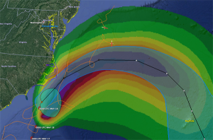
Observing System Experiments in support of the EEOOTT Integrated Field Campaign (CHAOS)
Matthieu Le Henaff, Hyun-Sook Kim, HeeSook Kang, Lewis Gramer*
Cooperative Institute For Marine And Atmospheric Studies (CIMAS) / NOAA Atlantic Oceanography and Meteorological Laboratory (AOML)
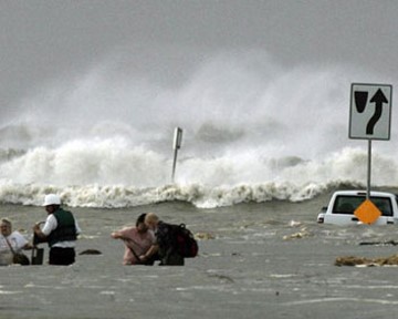
Targeted Aircraft-Based Measurements of the Air-Sea Transition Zone for Understanding Tropical Cyclone Intensity Change
Jun Zhang, Joseph Cione, Joshua Wadler*, Johna Rudzin*, Nick Shay
CIMAS / AOML, NOAA AOML, Embry-Riddle Aeronautical University, Mississippi State University, University of Miami
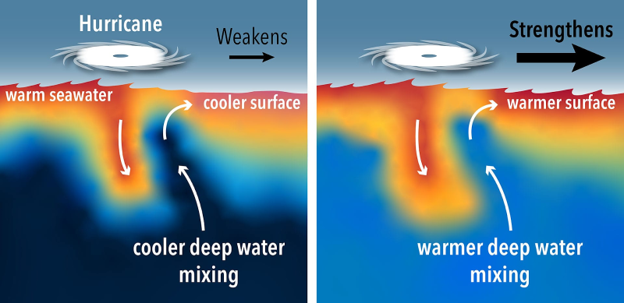
Gulf of Mexico Essential Features and Tropical Cyclone Air-Sea Interaction Gulf of Mexico
Stephan Howden, Kevin Martin
University of Southern Mississippi
Glider based observations of upper ocean mixing under hurricanes
Travis Miles*
Rutgers University
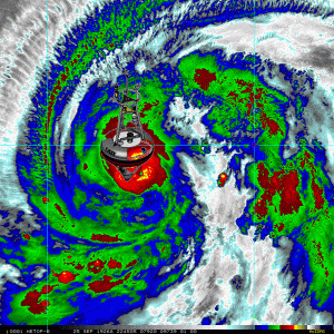
Remote Sensing of the Ocean Surface Winds and Waves and 3-D Atmospheric Winds in Hurricanes
Paul Chang, Zorana Jelenak, Joe Sapp*
NESDIS STAR
Profiling float observations for the EEOOTT Integrated Field Campaign (CHAOS)
Steve Jayne, Pelle Robbins, Alex Gonzalez*
Woods Hole Oceanographic Institution
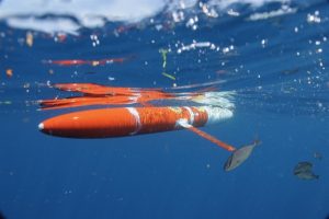
Concurrent observations of Directional Properties of Waves, Ocean Temperature and Air Pressure Under Hurricanes from Innovative Expendable Drifting Buoys
Luca Centurioni, Martha Schönau*
Scripps Lagrangian Drifter Laboratory
Integrated Observations of the Air-Sea Transition Zone of Atlantic Hurricanes in 2023 Using Combined Uncrewed Systems
Chidong Zhang, Greg Foltz, Gustavo Goni
NOAA Pacific Marine Environmental Laboratory, NOAA Atlantic Oceanography and Meteorological Laboratory

Ocean Observing Workshops​

In 2021, GOMO hosted a workshop on “Integrating Ocean Observations to Improve NOAA’s Hurricane Intensity Forecasts.” The workshop was co-led by NOAA’s U.S. IOOS and AOML, with keynote presentations from the NWS and the Office of Marine & Aviation Operations (OMAO) leadership. The workshop brought together over 100 experts in the ocean and atmospheric observing and modeling communities, and was critical for defining the key priorities for the CHAOS 2023 integrated field campaign. The main products coming out of this workshop include:

In 2023, GOMO Extreme Events program manager Cheyenne Stienbarger co-hosted a profiling float workshop at NOAA AOML, along with Greg Foltz (AOML) and Yi Chao (Seatrec / Gulf Blue Navigator Program). The workshop aimed to identify data gaps related to profiling floats in the Gulf of Mexico and Caribbean regions in order to prioritize observing needs in future hurricane seasons.

Partners of the GOMO Extreme Events Program

GOMO collaborates across several NOAA program offices that support hurricane observing, research, technology advancements, operations, modeling and forecasting in order to facilitate and coordinate the integration of ocean observations into these activities. GOMO also partners with researchers working at NOAA Labs and Cooperative Institutes as well as at academic institutions and universities, where much of the on-the-ground hurricane research is conducted.

NOAA Program Offices

NOAA Labs & Cooperative Institutes

Academic Partners & Universities

Extreme Events News & Resources​

GOMO Featured Stories

Stories from Extreme Events Partners

Resources

Cheyenne Stienbarger

Extreme Events Program Manager