Successful Deployment of KEO Ocean Climate Station
September 24 - 29, 2019:
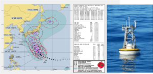
 Pacific Marine Environmental Lab (PMEL) and partners aboard the Kaiyo Maru #1 successfully completed the Kuroshio Extension Observatory (KEO) mooring turnaround cruise during typhoon season. The cruise began later than expected after facing delays due to typhoon Tapah. Sandwiched between weather systems, the KEO mooring was both deployed and recovered successfully in a single 24-hour period, and is ready to observe Super Typhoon Hagibis, demonstrating it’s dual-purpose of relaying real-time weather information and contributing to longer, climatological records. In addition to the mooring, four JAMSTEC backscatter meters and an underwater camera were deployed. The KEO mooring is also known as a “storm mooring” due to its prime location to observe the transition of tropical cyclones to extra-tropical storms and measure the exchanges of heat and moisture between the atmosphere and ocean associated with these storms. During the summer and fall months, typhoons are common in the western North Pacific. On average, a typhoon passes within 500NM of KEO every two weeks during the peak of the tropical cyclone season. The next typhoon (HAGIBIS) is expected to hit KEO on October 12, 2019 (See Figure).
Data from ocean climate stations moorings provide the foundation blocks for NOAA’s Climate Observation Division’s program deliverables of global climate analysis products. These measurements can be used to help improve weather and storm forecasts, inform climate projections, and verify satellite products and models. The Kuroshio Extension current carries warm water at nearly 140 million cubic meters per second eastward into the North Pacific, and is a region where the ocean generally loses heat to the atmosphere. The exchange of heat and moisture into the atmosphere is an important factor in the development of storms over the north Pacific before they reach the United States. Located about 360 miles southeast of Tokyo, the KEO mooring monitors air-sea interactions, ocean currents, and weather variation. KEO measures surface variables including temperature, humidity, atmospheric pressure, winds, rain, and radiation. Subsurface currents, salinity, temperature, and pressure are also recorded, with the deepest sensors near the seafloor in 5,700m of water. Hourly realtime data are available from transmissions every 6 hours, and higher resolution data (10 minutes or less) are downloaded upon recovery. For more details on the KEO mooring, see: http://www.pmel.noaa.gov/ocs/.
More Links
Successful Deployment of KEO Ocean Climate Station – Successful Deployment of KEO Ocean Climate Station