
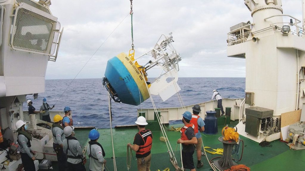
On February 28, 2023, a team of oceanographers from the Woods Hole Oceanographic Institution (WHOI) Upper Ocean Processes Group made the 21st replacement of the Stratus mooring. Since the mooring was initially deployed in October 2000, this achievement marks over 22 years of Stratus observations, making it one of the longest continuously occupied surface mooring locations in the world.
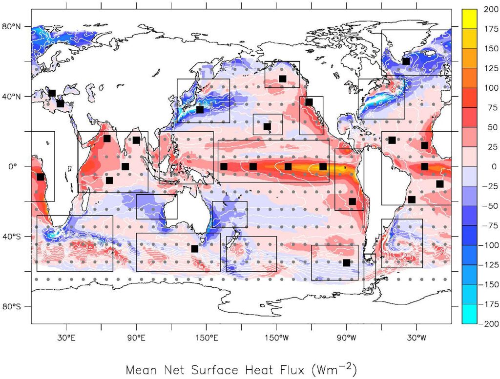
A research paper led by WHOI scientist Bob Weller was recently highlighted in the April 2023 issue of the Bulletin of the American Meteorological Society (BAMS) emphasizing the unique value of data collected from Stratus and two other moorings, including the WHOI Hawaii Ocean Time series Station (WHOTS) and the Northwest Tropical Atlantic Station (NTAS). This study revealed that global climate models significantly underpredict the amount of heat going into the ocean in trade-wind regions.
OceanSITES like Stratus provide high-quality data from fixed-point locations to help us monitor our ocean and climate.
The Stratus mooring is an OceanSITES reference station supported by the Global Ocean Monitoring and Observing Program (GOMO) that collects data on a variety of ocean and atmospheric variables to measure air-sea fluxes, including temperature, salinity, current and wind velocity, barometric pressure, radiation, and more. OceanSITES form an essential component of the Global Ocean Observing System by providing high-quality, high-frequency time-series data from important or representative fixed-point locations in the open ocean. These data are often transmitted in near real-time via satellites or radio telemetry to be immediately used by researchers. OceanSITES are critical to document the changes happening in our oceans and atmosphere. Data from the Stratus mooring has also been instrumental in detecting climate variability driven by the El Niño Southern Oscillation (ENSO), which causes a range of extreme weather phenomena globally.
OceanSITES data are used to verify climate models, and Stratus is revealing greater than predicted flux of heat into the ocean.
Stratus is strategically located in a data-sparse, persistently cloudy region of the eastern tropical Pacific off the coast of northern Chile where the ocean depth is 4,230 meters, or more than 2.6 miles. This ocean reference station is named after the persistent stratus clouds found west of Chile and Peru, which affect the ocean and atmospheric conditions in this region. Data from Stratus and other ocean reference stations are not incorporated into global climate models, but instead serve as an external check to validate and improve climate predictions. In the study led by Bob Weller, ocean heat flux data collected from the moorings was greater than predicted in global climate models.
The ocean is a major heat sink, storing as much as 90% of heat from global warming over the last 50 years. Accurately measuring how much heat goes into the ocean is critical for predicting global climate and warming trends, which are used to determine targets for reducing greenhouse gas emissions. The heat stored in the upper ocean also plays a major role in fueling tropical storms that threaten island nations and coastal residents, so assessing ocean heat flux is important for disaster preparedness and mitigation worldwide.
Maintaining OceanSITES stations is hard work and requires international collaboration.
The 21st replacement of Stratus is no small feat and the hard work that goes into maintaining these OceanSITES stations is surely something to be celebrated. Mooring replacements typically require weeks-long cruises every 12 months, often to remote locations and in difficult conditions. The scientists and crewmembers must be highly trained and work to ensure the mooring’s instruments are safely and accurately positioned in order to maintain the continuity of data from the site. Maintaining OceanSITES stations takes dedicated support, as well as collaboration and coordination across governmental, scientific, and international partners. The long-term data records available from OceanSITES are possible because of the commitment of GOMO to continually fund and support these stations, as well as of the researchers and engineers that help to maintain the moorings. Since 2015, the Stratus replacements have been achieved with the help of the Chilean Navy (Armada de Chile) and the Servicio Hidrográfico y Oceanográfico (SHOA), a Chilean agency similar to NOAA.
Sustaining OceanSITES and the long-term data they provide is crucial to understanding our changing ocean and climate.
Although the oceans make up 70% of our Earth, there are presently fewer than 300 OceanSITES stations, only about 20 of which are suited to study ocean-atmosphere interactions. GOMO supports several OceanSITES stations in collaboration with the WHOI Upper Ocean Processes Group and NOAA’s Pacific Marine Environmental Laboratory (PMEL), including Stratus, WHOTS, Station Papa, and KEO (previously also NTAS before it was recovered in October 2022). Yet, sustaining the OceanSITES network is not without challenges. The COVID-19 pandemic put an additional strain on our ability to sustain these long-term ocean observation systems due to restrictions on travel and increasing the cost of equipment, supplies, and shipping. These challenges caused a year-long delay in the 19th Stratus replacement, which occurred in 2021 after being rescheduled twice.
Despite these challenges, research continues to show that ocean reference stations are essential benchmarks that can identify gaps in ocean data, improve global climate models and ultimately help us reach climate targets around the world.
Read more about Stratus in WHOI’s Q&A interview with Bob Weller following the release of the April 2023 issue of BAMS.