Official websites use .gov
A .gov website belongs to an official government organization in the United States.

Secure .gov websites use HTTPS
A lock ( ) or https:// means you’ve safely connected to the .gov website. Share sensitive information only on official, secure websites.

Ocean Carbon Network

Jump to section

About the Program

Monitoring and observing ocean carbon helps us understand the broader effects of climate-related challenges on our planet

Image from Frontiers in Ecology and the Environment

The ocean absorbs approximately 25% of humankind’s carbon dioxide (CO2) emissions. While this reduces the accumulation of this greenhouse gas in the atmosphere, slowing the rate of climate change, it also increases the acidity of seawater (ocean acidification), endangering marine organisms and ocean health. 

NOAA’s Global Ocean Monitoring and Observing Program (GOMO) provides long-term observations of carbon from the sea surface to the sea floor. These measurements are recorded across the globe to capture differences between ocean basins at different time scales to capture both seasonal and year-to-year variability.

GOMO’s long-term monitoring and scientific analysis of how much carbon the ocean absorbs from the atmosphere is critical for understanding the role the ocean plays in regulating global climate, determining if ocean uptake of CO2 will continue at the same rate with increasing emissions, and how we can prepare for potential future climate-related challenges. These global observations are critical for the development of climate policies and future climate projections.

What We Measure

Surface Ocean Carbon

Understanding changes in oceanic CO2 uptake is essential for assessing the difference  between human-caused climate change and the global carbon cycle. The Surface Ocean CO2 Reference Network (SOCONET) provides information on how the global carbon cycle changes over time. This network utilizes commercial and research ships (Ship of Opportunity) and autonomous platforms to measure temperature, salinity, and pCO2 (partial pressure of carbon dioxide) in surface water and the air. These observations are used to determine the amount of atmospheric CO2 absorbed by the ocean on seasonal scales, document changes in the surface ocean carbon chemistry, and evaluate the variability in carbon exchange between the ocean and atmosphere to provide meaningful projections of future atmospheric CO2 levels.

Arctic wave glider measuring carbon air-sea exchange. Image Credit: Evans PMEL Climate Research
NOAA Ship Ronald H. Brown
Image Credit: NOAA PSL
Ocean Interior Carbon

Ship-based ocean sampling remains the only method for obtaining high-quality physical, chemical, and biological measurements from the surface to sea floor on a global scale. The U.S. Global Ocean Ship-based Hydrographic Investigations Program (U.S. GO-SHIP), part of the international GO-SHIP network of 55 sustained hydrographic sections, collects ocean interior carbon measurements to determine changes in the storage of human-caused CO2, including at depths greater than two kilometers, which is below what autonomous core Argo floats can measure.

How We Measure: Ocean Observing Tools

Ships

The Global Ocean Ship-based Hydrographic Investigations Program (U.S. GO-SHIP) is a network of global cruise tracks that cover the ocean basins from coast to coast and top to bottom. Each track is occupied every 10 years and the data collected provide information about changes in ocean heat, circulation patterns, carbon and oxygen content and more.

The Ships of Opportunity network utilizes volunteer commercial ships and research vessels. These ships are outfitted with sensors that collect data passively, greatly increasing our capacity to measure CO2 all over the ocean.

CTD Rosette

CTD rosettes are deployed from research vessels to measure Conductivity (salinity), Temperature, and Depth (CTD) and collect discrete water samples. The rosette, equipped with Niskin water sample bottles, is lowered through the water column to the bottom of the ocean. Each bottle collects a water sample at a specified depth. Once back on the ship, scientists analyze the water to measure carbon and other variables.

Buoys

NOAA maintains a network of moored buoys (fixed, measuring in one place) that measure atmospheric and surface ocean CO2. This provides a record of how CO2 concentrations change over time at a particular location.

Autonomous Surface Vehicles

Autonomous surface vehicles (e.g. saildrones) sail across the ocean collecting atmospheric and surface ocean CO2 measurements.

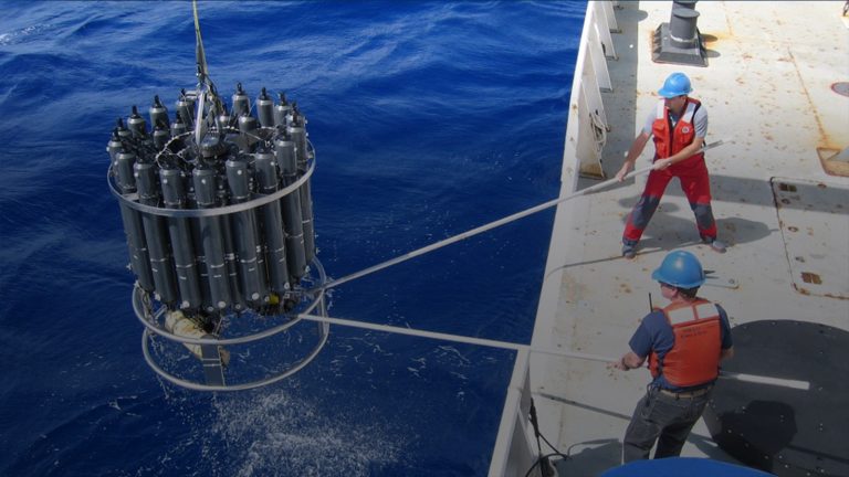
Biogeochemical (BGC) Argo Floats

These autonomous robotic profiling floats can collect vertical profiles of ocean temperature, salinity, pH, oxygen, nitrate, chlorophyll a, suspended particles, and downwelling irradiance from the surface to a depth of 2,000 meters every 10 days and transmit data in real-time via satellites.

GOMO's Role

GOMO is leading the coordination and integration of global ocean carbon observations across research and modeling activities

GOMO supports research that includes ocean carbon and biogeochemical observations, research, modeling, data synthesis, product development, and technology development. GOMO provides strategic programmatic support, facilitates partnerships, and supports capacity development. See who we work with by clicking the icons below.

Ocean Carbon News

Funding will expand observations, improve forecasting of carbon dioxide levels in the ocean surface and atmosphere This is a repost of a NOAA.gov press release published May 30, 2024. Today,...

U.S. GO-SHIP is looking for students to participate in the upcoming occupation of the meridional hydrographic line known as A16S aboard the NOAA Ship Ronald H. Brown. The cruise is...

This is a repost of NOAA AOML’s original story published May 2, 2024. Floating ice, freezing temperatures, and streaks of lights in the night sky. Traversing from Fremantle, Australia to Antarctica’s...

This is a repost of NOAA AOML’s original story published April 22, 2024. Wind, waves, and icebergs pierced through morning fog – the A13.5 GO-SHIP cruise proved both tumultuous and...

This is a repost of NOAA AOML’s original story published February 13, 2024. Scientists at NOAA’s Atlantic Oceanographic and Meteorological Laboratory (AOML) are gearing up for a busy season at...

This is a repost of a NOAA Research article published December 5, 2023. Read the original post here. NOAA data and models help scientists track the global carbon cycle Greenhouse...