It’s no secret that our oceans are getting warmer. Ocean heat is a topic that spans across all of NOAA: from its influence on extreme weather events and Arctic sea-ice extent, to its impact on fisheries and marine ecosystems at all latitudes, it is clear that our ability to monitor the changes in ocean temperature is foundational to NOAA’s mission. While NOAA satellites are able to measure ocean heat from space, having instruments in the water (in-situ) to “ground-truth” those measurements is critical. That’s where NOAA’s Global Ocean Monitoring and Observing Program (GOMO) comes in.
Thanks to collaborations with academic and cooperative institutes, technological advances arising from partnerships with the private sector, and invaluable insights from local and Indigenous community partners, GOMO is able to support and sustain continuous, long-term measurements of ocean temperatures that allow us to track how ocean temperatures are increasing in space and time.
There are many instruments in the ocean monitoring and observing toolkit, but they can be clustered into three categories, each gathering valuable measurements and generating data that collectively serve as a global ocean “thermometer.”
The ones we deploy from ships.
CTD Rosettes
CTD rosettes are deployed from research vessels to measure conductivity (salinity), temperature, and depth. As the rosette descends through the water column, the attached bottles collect water samples from different depths. This allows for a comparison of ocean measurements, including heat, from the surface to the seafloor. Additional sensors that detect other useful oceanographic properties, like oxygen, pH, chlorophyll content, and water velocity, may be added to the rosette, allowing scientists to see how those components change with changing ocean temperature.
XBTs
Expendable bathythermographs (XBTs) can take the temperature of the upper 1,000 meters of the ocean, and have been deployed from research vessels and other Ships of Opportunity for over 60 years! XBTs consist of a launcher, a long cable system, and a weighted probe that extends the cable system through the water. Copper wires within the cable system record temperature through the water, and deliver measurements of ocean heat back to the ship. Approximately 10,000 XBTs are deployed each year!
The ships themselves
NOAA’s fleet of 15 ships are homeported across the United States, from Hawai`i to Alaska, and California to Rhode Island. The geographic distribution and range of research capabilities on every ship enables support of NOAA’s oceanographic missions in each ocean basin. CTDs and XBTs are housed on many of NOAA’s ships, and several vessels can also sample ocean water while underway! This expanding fleet is paramount in collecting ocean data to monitor ocean temperatures.
The ones that stay in place.
Moored Buoys
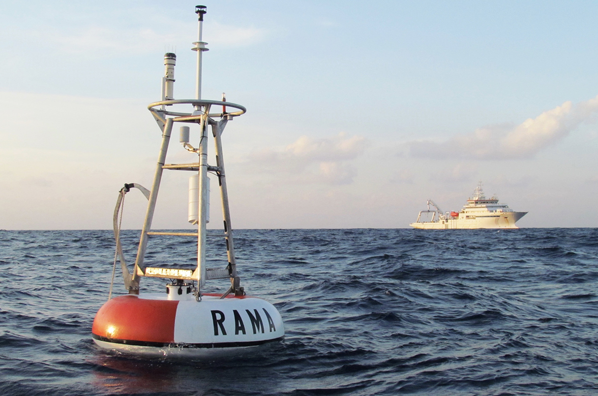
You’ll need to look below the surface to fully appreciate the ocean monitoring abilities of GOMO’s moored buoys. These keystone instruments are composed of a floating buoy at the water’s surface that is tethered to the seafloor by a mooring line. Both components are outfitted with various sensors that measure temperature, among several other ocean variables, in the air, in the upper ocean, and through the water column. By maintaining moored buoys in the same location year upon year, we can observe changes in ocean temperature on a regional scale.
Tide Gauges
Ocean heat impacts sea level through thermal expansion – the growth of water molecules with increasing temperature. Tide gauges around the world measure the amount of sea-level change and help track changes in our coastlines. Long-term data from tide gauges have many applications, from guiding coastal community resilience strategies to informing coastal ecosystem conservation and management. Through the Global Sea Level Observing System, GOMO funds over 50 tide gauges across the world!
The ones that swim around the ocean.
Autonomous Vehicles
These robotic collectors of ocean data come in two flavors, autonomous surface vehicles (ASVs) and autonomous underwater vehicles (AUVs). One example of an ASV is the Saildrone, which collects high-quality data of air and surface ocean conditions for up to a year! Ocean heat measurements from Saildrone are used to support NOAA’s hurricane forecasts in the Atlantic. Underwater, gliders are AUVs that have mini-CTDs built into their torpedo-shaped bodies. Glider missions may last up to six months, and through global and regional networks, these instruments are measuring heat at different depths in the ocean.
Argo Floats
Over three million profiles of ocean data have been collected by these autonomous profiling floats. Since the program’s inception in 1999, Argo float design has advanced to measure the deep ocean (down to 6,000 meters), and feature sensors that take biological and chemical measurements. Argo data are open and free to the public, and are used to test and calibrate ocean and climate models used for forecasting. The Argo Program has revolutionized our ability to track changes in the ocean, providing nearly four times the ocean information as all other observing tools combined.
Surface Drifters
Surface drifters are aptly named, as these instruments are placed in the ocean and left to drift in the water, guided by winds and surface currents. Today, more than 1,300 satellite-tracked drifters are out at sea collecting data on currents, atmospheric pressure, winds, waves, and salinity. They also measure sea surface temperature, which is a critical measurement needed to validate measurements of ocean heat taken from space (i.e., by satellites!). Students across the globe engage with oceanography and marine science through NOAA’s Adopt a Drifter Program, which provides lesson plans and GPS information to track an actual drifter!
These three categories of global ocean thermometers have generated billions of measurements in recent decades, and these measurements have been integral in determining where, why, and how quickly global ocean temperatures are rising. However, recent observations continue to challenge our understanding of important ocean-climate dynamics, like the El Niño Southern Oscillation (ENSO) and the Atlantic Meridional Overturning Circulation. We still have much to learn about the complexities of a warming ocean and its impact on weather and climate across the globe. These observations highlight the critical need to continue supporting and expanding the network of global ocean “thermometers.”
Through GOMO, NOAA supports over one million ocean observations, including heat, every day!
Even so, vast regions of the global ocean remain unmapped, unobserved, and unexplored. Learn more about ocean heat, the different impacts it has on communities and ecosystems from the sea to the sky, and GOMO’s contribution to the global ocean observing system.


